Terrington, Ganthorpe, Wiganthorpe and Mowthorpe in Domesday
Background
Following the Norman invasion and conquest of England in 1066, the Domesday survey was commissioned in December 1085 by order of King William I. William needed to raise more taxes and the survey was organised to assess the taxable wealth and assets of his subjects throughout the country. He was interested in the amount of agricultural land, the numbers of people working it, mills and churches, all of which could be taxed.
The information was collected by Royal commissioners who were sent out to each county. It is thought that England was split into 7 regions, or ‘circuits’, with 3 or 4 commissioners being assigned to each. Yorkshire was in a circuit with Derbyshire, Huntingdonshire, Lincolnshire, Nottinghamshire and Rutland.
The commissioners had a set of questions which they put to a jury of representatives in each county. Once they returned to London the information was combined with earlier records, from both before and after the Conquest, and was then entered, in Latin, into the final Domesday Books. These were first published in 1086, and contain 413 pages with records for 13,418 settlements in the English counties south of the rivers Ribble and Tees (the border with Scotland at the time).
Domesday Book comprises two volumes, Great and Little Domesday. Great Domesday contains the final summarized record of all the counties surveyed except Essex, Norfolk, and Suffolk. For these three counties the full, unabbreviated return sent in to Winchester by the commissioners is preserved in the second volume (Little Domesday), which, for some reason, was never summarized and added to the larger volume. The books are currently housed at The National Archives, Kew.
Within each county (or riding in Yorkshire) the entries are organised by tenant-in-chief and within these by wapentake then by settlement. A wapentake is an administrative area in the northern and eastern counties and Terrington is in the wapentake of Bolesford which later became known as Bulford or Bulmer wapentake which stretched from the Ouse and Swale in the west to the Derwent in the east and from the boundary of York in the south to the Howardian Hills in the north.
The arrangement by wapentake makes it difficult to find all entries relating to Terrington, for example, as they are divided among a number of landholders. There is for Yorkshire, however, another section of the book which organises the entries by settlement, so all holdings in each settlement are together. This may correspond more closely to the way in which the material was first organised, before being re-organised by landholder.
The spelling of names can be quite varied.
Terrington appears variously as Teurinctun, Teurinctune, Teurinton, Teurintone, and Teurintune.
Ganthorpe appears as Gameltorp and Galmetona.
Wiganthorpe appears as Wichgastorp, Wichingastorp.
Mowthorpe appears as Muletorp.
Two useful websites on the Domesday survey and book are:
A classic text on Domesday is Domesday Book and Beyond: Three Essays in the Early History of England, by Frederic Maitland, published in 1913.
These links go to the pages for the settlements in the current Terrington Parish in Open Domesday:
Mowthorpe does not appear, but see later for more information.
Some terms used
The meaning of a number of terms are used in Domesday can be difficult to pin down, such as:
Wastum or wasta, translated as waste but it is a term which is still subject of much debate among scholars. There is a great deal of this in Yorkshire and it is often said that it refers to land which was laid waste in the harrying of the North in 1069-70 but it seems unlikely that is would still be waste some 15 years later. It may indicate that the land is not currently being taxed for some reason.
Carucata and bovata are areas of land. A carucate was roughly the area of land which one plough team of 8 oxen could plough in an annual season. This would depend on the conditions but is usually assumed to be about 120 acres. A bovate is one-eighth of a carucate.
Caruca a plough
Ad geldum is usually translated as 'to the geld', ie taxable.
Manerium - translated as manor but may just mean a house from which the estate is administered. A medieval manor is usually thought of as an economic unit with its own court to deal with infringements and disputes. Such private justice may be a later developement and the wapentake court may have been responsible for this at the time of Domesday Book.
Dominio (Desmesne) - the area kept by the lord for himself rather than being tenanted. The tenants on the rest of the land (villains and bordars) would, in exchange for their land, be required to work on the desmesne for a certain number of days.
The three classes of workers mentioned in our parish are villanus (villain), bordarius (bordar) and sochmanius (sokeman). Villains and bordars are regarded as being tied to the land they work and to owe labour to their lord, with villains having a larger area of land than bordars. Sokemen are regarded as being free men.
Some useful words which appear in the entries for Terrington, usually abbreviated are:
dimidium (abbreviated dim) = half
quarentina (quar) = a furlong. A furlong is the length of the furrow ploughed by a team of oxen before turning the plough. It is often thought of as being 40 perches, ie 220 yards, in length though it would have depended on the shape of the field, the nature of the soil, and other factors.
leuga or leuca (leu) = a league. There is no agreement as to the extent of a league. It is sometimes taken to be 12 furlongs or it may have been used as a synonym for a mile.
ecclesia (eccla) = a church
presbyter (pbr) = a priest
molendinum (mold) = a mill
silva pastilis (silua past) = wood pasture
prata (pa) = meadow
solidus (sol) = a shilling, the usual unit of currency used
Landholders in the parish
Terrington, Ganthorpe, Wiganthorpe and Mowthorpe each appear separately in Domesday and their lands were allocated to 4 people: King William and three tenants-in-chief, Count Robert of Mortain, Count Alan of Brittany, and Berengar of Tosny. The links below go to the relevant page in Open Domesday and show the extent of the land of each landholder.
King William kept the largest share of land for himself throughout the country.
Count Robert of Mortain (c1031-c1095) was William's half brother (same mother, different fathers) and was the largest land holder in the country after the King and held lands in Yorkshire, the Midlands, Cornwall and elsewhere.
Count Alan of Brittany, Alan Rufus or Alan the Red (c1040-1093) was the King's second cousin and held the Honour of Richmond, important in securing the northern border, and scattered lands in Yorkshire, Lincolnshire, East Anglia and Cambridgeshire.
Berengar de Tosny (before 1045-c1116) of Belvoir Castle, whose family originated in Normandy, had scattered lands in Yorkshire and Lincolnshire.
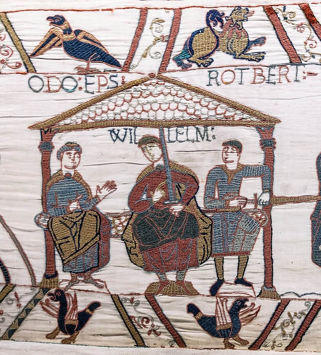
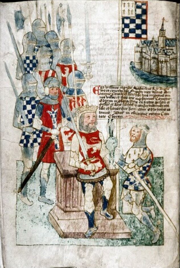
The Bayeux tapestry shows King William with his half brothers Count Robert of Mortain and Bishop Odo of Bayeux and a 14th century illuminated manuscript shows Count Alan swearing fealty to William I.
The lands of King William
The King had lands in Wiganthorpe and in Ganthorpe (Folio 300v):

Translation:
In Wiganthorpe. Knut. 1 carucate to the geld. Land for half a plough.
This indicates that the land belonged to Knut before the conquest.
"To the geld" means that the land is taxable. Here the 1 carucate seems only to need half a plough? Was some of the land not ploughed?

Translation:
In Ganthorpe. Gamel. Half a carucate to the geld.
This indicates that the land belonged to Gamel before the conquest. The entries for the King are all very brief with no mention of the numbers of people working the land and, as here, the number of ploughs there are or could be.
The lands of Count Robert of Mortain
There are two entries for Count Robert in the parish, one relating to lands in Ganthorpe and Terrington, and the other to lands in Terrington and Wiganthorpe (Folio 306r):
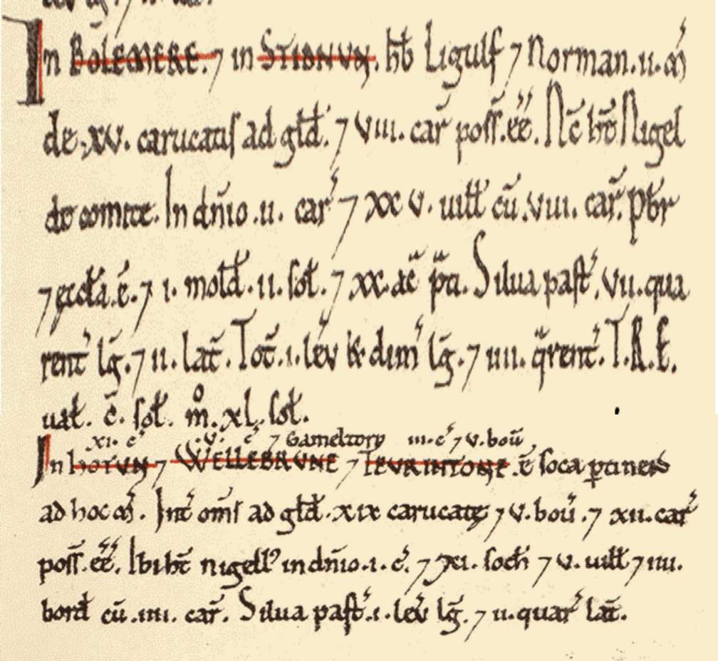
In Hotun xi carucatae et Wellebrune v carucatae et Teurintone et Gameltorp iii carucatae et v bovatae est soca pertinens ad hoc manerium. Inter omnia (or omnes) ad geldum xix carucatae et v bovatae et xii carucae possunt esse. Ibi habet nigellus in dominio i carucatam et xi sochemannos et v villanos et iiii bordarios cum iiii carucis. Silva pastilis i leucae longitudine et ii quarentinarum latitudine.
Translation:
In Bulmer and High Stittenham, Ligulf and Northmann had 2 manors of 15 carucates to the geld, and there could be 8 ploughs. Now Nigel has them of the count. In demesne [are] 2 ploughs and 25 villains with 8 ploughs. There is a priest and a church, and a mill [rendering] 2s and 20 acres of meadow. Woodland pasture 7 furlongs long and 2 broad. The whole [is] 1 and a half leagues long and 4 furlongs [broad]. In the time of King Edward it was worth 100s, now 40s.
In Sheriff Hutton, 11 carucates, and Welburn [in Bulmer], 5 carucates, and Ganthorpe and Terrington, 3 carucates and 5 bovates, is sokeland belonging to this manor. In all, [there are] 19 carucates and 5 bovates to the geld, and there could be 12 ploughs. Nigel has 1 plough there in demesne and 11 sokemen and 5 villains and 4 bordars with 4 ploughs. [There is] woodland pasture 1 league long and 2 furlongs broad.
The land in Sheriff Hutton, Welburn, Ganthorpe and Terrington is said to be 'sokeland belonging to' (ie is in the jurisdiction of) the holding in Bulmer and High Stittenham. It contains a considerable area of woodland pasture. Nigel is the Count Mortain's tenant. Bulmer has a priest, a church and a mill but there is no mention of any of these in Terrington in Domesday Book.
It is not clear from this entry how much land is in Ganthorpe or whether it is included in the 5 carucates in Welburn. The Yorkshire Summary (see later) says that Mortain had 3½ carucates in Welburn and 2½ carucates in Ganthorpe. So, if Ganthorpe here is included in the Welburn lands, Welburn should have 6 carucates in total.

Translation:
In Terrington and Wiganthorpe, Waltheof had one manor of 3 carucates and 6 bovates to the geld. Now Count Robert has it, and it is waste. In the time of King Edward it was worth 10s.
This land is waste (ie not currently taxed?) whereas in the time of Edward the Confessor it was valued (for taxable purposes) at 10s.
The lands of Count Alan
Count Alan has one holding in Terrington (Folio 313r):
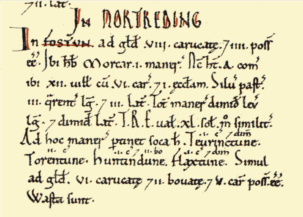
In Fostun ad geldum viii carucatae et iiii [carucae] possunt esse. Ibi habebat Morcar i manerium. Nunc habet Alan comes ibi xii villanos cum vi carucis et i ecclesiam. Silva pastilis iii quarentinarum longitudine et iii latitudine. Totum manerium dimidii leucae longitudine et dimidium latitudine. Tempore Regis Edwardi valuit xl solidos modo similiter.
Ad hoc manerium pertinet soca haec Teurinctune i carucata et dimidium Torentune ii carucatae Huntindune i carucata et ii bovatae Flaxtune i carucata et dimidium. Simul ad geldum vi carucatae et ii bovatae et v carucae possunt esse. Wasta sunt.
Translation:
IN THE NORTH RIDING
In Foston [are] 8 carucates to the geld, and there could be 4 [ploughs]. Morcar had 1 manor there. Now Count Alan has there 12 villains with 6 ploughs, and 1 church. [There is] woodland pasture 3 furlongs long and 3 broad. The whole manor [is] half a league long and a half broad. In the time of King Edward it was worth 40s; now the same.
To this manor belongs this sokeland: Terrington, 1½ carucates; Thornton-le-Clay, 2 carucates; Huntington,1 carucate and 2 bovates; Flaxton, 1½. Together, [there are] 6 carucates and 2 bovates to the geld, and there could be 5 ploughs. They are waste.
This land in Terrington is soke to Foston and is waste.
The lands of Berengar of Tosny
Berengar has two holdings in the parish, one in Terrington and one in Wiganthorpe (Folio 314r):

Translation:
In Terrington [are] 2 bovates to the geld. [There is] land for 2 oxen.

Has terras habuit Gamel et nunc Berenger habet sed wastae sunt omnes.
Translation:
In Wiganthorpe [is] 1 carucate to the geld. [There is] land for half a plough.
Gamal had these lands, and now Berengar has them, but they are all waste.
The Yorkshire Summary
The Yorkshire section of Domesday book also has a Summary which orders the holdings by settlement, so the holdings of the various tenants-in-chief in each settlement are together. This seems closer to the organisation of the data as it was collected and from which the ordering in the main part of the book was derived. For the Bulford wapentake we have (Folio 380v):
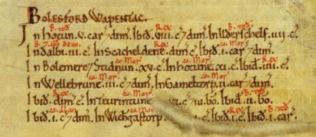
In Ganthorpe, comes Mortain ii carucatas et dimidium.
Ibidem Rex dimidium carucatae. In Terrington, comes Mortain vi carucatae et iii bovatae. Ibid Berengar de Tosny ii bovatae.
Ibidem comes Alan i carucata et dimidium. In Wiganthorpe comes Mortain i carucata. Ibidem Rex i carucata. Ibidem Berengar de Tosny i carucata.
Translating and dividing more clearly by settlement we have:
Bulford wapentake
In Ganthorpe, the Count of Mortain 2½ carucates. In the same place, the king half a carucate.
In Terrington, the Count of Mortain 6 carucates and 3 bovates. In the same place, Berengar de Tosny 2 bovates. In the same place, Count Alan 1½ carucates.
In Wiganthorpe, the Count of Mortain 1 carucate. In the same place, the king 1 carucate. In the same place, Berengar de Tosny 1 carucate.
There is no mention of Mowthorpe here, nor in the main entries earlier under tenant-in-chief.
At the end of the Bolesford wapentake we have, almost as an afterthought:

Translation:
In Low Mowthorpe [in Terrington], the Count of Mortain 3 carucates. In Shipton, Count Alan 6 carucates. In Bossall, 2½ bovates.
This 3 carucates to the Count of Mortain is a puzzle. It does not figure in the main part of the book under the Count of Mortain's holdings and in the Summary it is not with the entries for Ganthorpe, Terrington, and Wiganthorpe, but is placed with Shipton and Bossall.
The Penguin Domesday book and the National Archives give the translation of Muletorp as 'Low Mowthorpe [in Terrington]'. There is a Low Mowthorpe near Duggleby but that is not in the Bolesford wapentake.
Addendum: The lands of Robert de Bruis
There is one later addition for land given after the book of Winchester (ie Domesday Book) was written, if we accept that Galmetona means Ganthorpe (Folio 332v):

Translation:
THIS IS THE FIEF of Robert de Bruis which was given after the book of Winchester was written. Namely. (p855)

Translation:
In Low Hutton 3 carucates. In Ganthorpe half a carucate. In Brompton [near Snainton].
The Penguin Domesday book and the National Archives give the translation of Galmetona as Ganthorpe. It's not clear why. Also, is this new land or is it taken from one of the existing landholders?
Summary
The land holdings can be summarised as follows. c stands for carrucate and b for bovate and there are 8 bovates in a carrucate. bc indicates the landholder before the Conquest.
| King | Mortain | Count Alan | Berengar | Totals | |
|---|---|---|---|---|---|
| Ganthorpe | 0c4b bc Gamel | 2c4b (soke to Bulmer) bc Ligulf and Northmann now tenant Nigel | - | - | 3c0b |
| Terrington | - | 3c5b (soke to Bulmer) bc Ligulf and Northmann now tenant Nigel 2c6b* (with Wiganthorpe) bc Waltheof now waste | 1c4b (soke to Foston) bc Morcar now waste | 0c2b bc Gamal | 8c1b |
| Wiganthorpe | 1c0b bc Knut | 1c0b* (with Terrington) bc Waltheof now waste | - | 1c0b bc Gamal now waste | 3c0b |
| Mowthorpe | - | 3c0b** | - | - | 3c0b |
| Totals | 1c4b | 12c7b | 1c4b | 1c2b | 17c1b |
* Under Mortain's holdings these appear as a single manor of 3 carrucates and 6 bovates in Terrington and Wiganthorpe, but the Yorkshire Summary allows us to work out how much is in each settlement.
** This holding of 3 carrucates only appears at the end of the Yorkshire Summary and not under Mortain's landholdings.
This table does not include the 0.5c in Ganthorpe given to Robert de Bruis after Domesday Book was written.
Note that, if we take a carrucate as 120 acres, in total only about half of the current parish of Terrington is accounted for.
Ganthorpe's 3c would be 360 acres whereas the parish of Ganthorpe which existed until 1974 had an area of about 730 acres.
The 14c1b for Terrington, Wiganthorpe and Mowthorpe would be 1695 acres whereas the pre-1974 parish of Terrington with Wiganthorpe which included Mowthorpe had an area of about 3220 acres.
Presumably the areas given in Domesday Book are for land under the plough and do not include areas such as pastures, commons and woodland.
Excluding Mowthorpe about which there are no details, 6 carrucates and 2 bovates out of 14 carrucates and 1 bovate (44%) is waste.
